2022. 10. 12. 07:42ㆍ기공 강의 연구 자료/우리는 어디에 있나?
우리는 어디에 있나?
"최고 시야의 지구
Earth in Full View

아폴로 17호 승무원이 1972년 달으로 여행하고 있던 중, 우리의 고향 행성의 이 숨막히는 장면을 찍었다. 우주인들이 남극의 만년설을 사진 찍을 수 있었던 것이 이것이 처음이다. 아라비아 반도와 함께 거의 모든 아프리카 해안선이 분명히 보인다.
나사(미국 항공 우주국)
The Apollo 17 crew caught this breathtaking view of our home planet as they were traveling to the Moon in 1972. It's the first time astronauts were able to photograph the South polar ice cap. Nearly the entire coastline of Africa is clearly visible, along with the Arabian Peninsula.
Image Credit: NASA"
(출처: http://www.nasa.gov/multimedia/imagegallery/image_feature_329.html )
Earth in Full View From Apollo 17
The Apollo 17 crew -- astronaut Eugene A. Cernan, commander; astronaut Ronald E. Evans, command module pilot; and scientist-astronaut Harrison H. Schmitt, lunar module pilot -- caught this breathtaking view of our home planet as they were traveling to the
www.nasa.gov
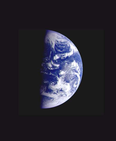
"2000년 푸른 공깃돌의 화상
Image of the Blue Marble 2000
아래의 지구 화상과 구름은 미국 해양 대기국(NOAA)에서 운영하는 지구 정지 궤도 환경 위성(GOES)에 의해 1997년 9월 9일 찍어졌다, 그리고 1997년 나사(미국 우주 항공국)에 의해 만들어졌다. 해양의 색깔은 1997년 9월 말과 10월초에 나사의 바다 보기 광각 센서 위성(SeaWiFS)에 의해 수집 되어졌다. 땅의 색깔은 미국 해양 대기국(NOAA)의 극 궤도 순환 환경 위성(POES)에 탑재된 진보한 극 고해상도 라디오 미터(AVHRR)에 의해, 1997년 9월 9일-19일까지 수집된 식물의 생장 지수에 의해 그려졌다.
The underlying image of the full disk of Earth and its clouds was taken on September 9, 1997, by a Geostationary Operational Environmental Satellite (GOES) operated by the U.S. National Oceanic and Atmospheric Administration (NOAA), and built by NASA. The ocean color data was collected in late September and early October 1997 by NASA's Sea-viewing Wide Field-of-view Sensor (SeaWiFS) satellite. The land color is portrayed by a vegetation index calculated using data collected from September 9-19, 1997, by Advanced Very High Resolution Radiometer (AVHRR) instruments carried aboard NOAA's Polar Orbiting Environmental Satellites (POES). " Credit: NASA
(출처: http://www.nasa.gov/vision/earth/features/bm_gallery_5.html )
NASA - Image of the Blue Marble 2000
Image of the Blue Marble 2000 The underlying image of the full disk of Earth and its clouds was taken on September 9, 1997, by a Geostationary Operational Environmental Satellite (GOES) operated by the U.S. National Oceanic and Atmospheric Administration (
www.nasa.gov
"2002년 푸른 공깃돌의 화상
Image of the Blue Marble 2002
이 화상에 포함된 많은 정보는 단일 원거리 감지 기계-나사의 “보통 해상도 화상 스펙트럼 라디오 미터(MODIS)”로부터 왔다. 나사의 지표 관측 위성(Terra satellite) 위에 탑재되어 지구 위 700Km 고도를 비행하면서, MODIS는 지구의 토질, 해양, 그리고 대기의 특성의 다양성을 관측하기 위하여 종합적인 도구로서의 기능을 한다. 이 화상의 육지와 해안선 부분은 2001년 6월부터 9월을 통하여 수집된 지상의 관측을 근거로 한다, 그리고 단 하루 동안이라도 센서의 시야를 가릴지 모르는 구름을 보정하기 위하여 매 8일 마다 합체되고 그리고 합성되었다. 두 가지 다른 형태의 해양 자료가 이들 화상에 사용되었다: 얕은 바다 트루 칼라 정보와 지구의 해양 컬러(또는 클로로필, 엽록소) 정보.
Much of the information contained in this image came from a single remote-sensing device-NASA’s Moderate Resolution Imaging Spectroradiometer, or MODIS. Flying over 700 km above the Earth onboard the Terra satellite, MODIS provides an integrated tool for observing a variety of terrestrial, oceanic, and atmospheric features of the Earth. The land and coastal ocean portions of these images are based on surface observations collected from June through September 2001 and combined, or composited, every eight days to compensate for clouds that might block the sensor’s view of the surface on any single day. Two different types of ocean data were used in these images: shallow water true color data, and global ocean color (or chlorophyll) data.
지형도의 미세한 변화는 미국 지질 조사국의 지구 자원 관측과 과학(Earth Resources Observation and Science, EROS) 데이터 센터에 의해 편집된 글로벌 수치 표고 모델(Digital Elevation Model, DEM)인 GTOPO-30 위성의 고도 데이터 셋트에 기초하였다. 극지방 바다 얼음의 MODIS 관측은 국립 해양 대기국(NOAA)의 진보된 아주 높은 해상도 라디오 미터(AVHRR)에 의하여 작성된 남극의 관측 결과와 결합되었다. 구름의 화상은 가시광선 파장 내에서 수집된 화상의 이틀 동안 그리고 극지방 위쪽의 열 적외선 화상의 삼일 동안의 합성이다. 국방부의 기상 위성 프로그램으로부터 유래한 전 지구적 도시의 불빛은 어두운 지표 지도 상에서 중첩되었다.
Topographic shading is based on the GTOPO 30 elevation dataset compiled by the U.S. Geological Survey’s EROS Data Center. MODIS observations of polar sea ice were combined with observations of Antarctica made by the National Oceanic and Atmospheric Administration’s AVHRR sensor—the Advanced Very High Resolution Radiometer. The cloud image is a composite of two days of imagery collected in visible light wavelengths and a third day of thermal infra-red imagery over the poles. Global city lights, derived from 9 months of observations from the Defense Meteorological Satellite Program, are superimposed on a darkened land surface map.“
Credit: NASA
(출처: http://www.nasa.gov/vision/earth/features/bm_gallery_6.html )
NASA - Image of the Blue Marble 2002
Image of the Blue Marble 2002 Much of the information contained in this image came from a single remote-sensing device-NASA’s Moderate Resolution Imaging Spectroradiometer, or MODIS. Flying over 700 km above the Earth onboard the Terra satellite, MODIS p
www.nasa.gov
"지구가 뜬다
Earthrise
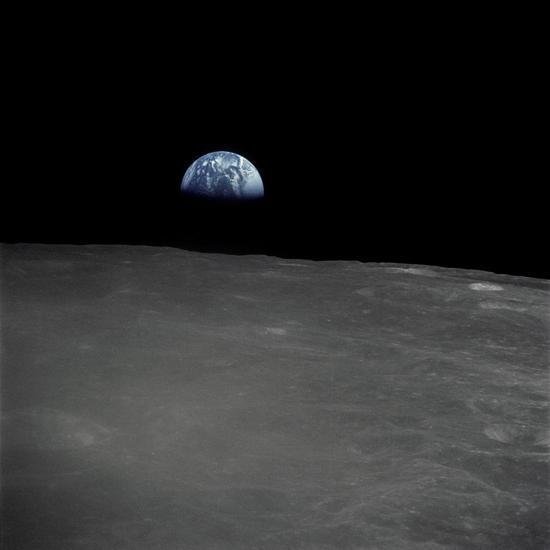
(사진 출처: http://www.nasa.gov/images/content/331786main_as16-120-19187_full.jpg )
아폴로 16호 승무원이 달을 2 바퀴 도는 동안 손으로 잡은 하셀블라드 카메라로 이 지구가 뜨는 장면을 찍었다. 달위에 보인 식별할 수 있는 분화구는 사하, 와일드 그리고 셍어 분화구를 포함한다. 지휘선이 달의 ‘어두운 부분’이라고 알려진 위로 통과할 때, 여기 보이는 많은 땅은 지구로부터는 결코 보이지 않는다.
The Apollo 16 crew captured this Earthrise with a handheld Hasselblad camera during the second revolution of the moon. Identifiable craters seen on the moon include Saha, Wyld and Saenger. Much of the terrain seen here is never visible from the Earth, as the command module was passing onto what is known as the 'dark side' of the moon.
아폴로 16호는 1972년 4월 16일 발사되었고, 그리고 4월 20일 달 위에 착륙했다. 이 임무는 존 영이 지휘하였다; 토마스 마팅리 2세가 지휘선의 조종사였고 그리고 찰스 듀크 주니어가 달 착륙선의 조종사였다.
Apollo 16 launched on April 16, 1972 and landed on the moon on April 20. The mission was commanded by John Young; Thomas K. Mattingly II was the command module pilot and Charles M. Duke, Jr. served as the lunar module pilot."
Image Credit: NASA
(출처: http://www.nasa.gov/multimedia/imagegallery/iotd.html )
NASA Image of the Day Gallery
NASA.gov brings you the latest images, videos and news from America's space agency. Get the latest updates on NASA missions, watch NASA TV live, and learn about our quest to reveal the unknown and benefit all humankind.
www.nasa.gov
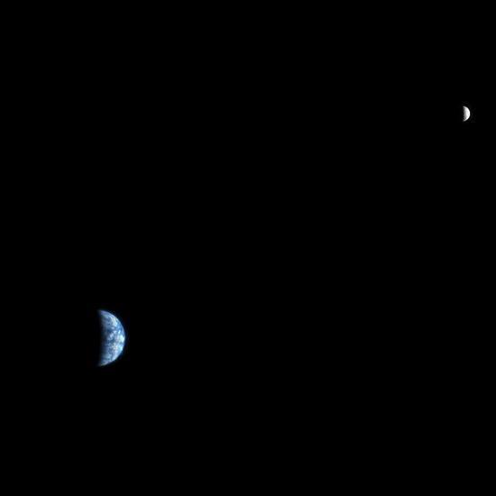
"지구 - 갈릴레오 우주선이 목성으로 향하여 떠나면서 찍은 화상
Earth - Departing Image by Galileo
이 지구의 칼라 화상은 갈릴레오 우주선이 목성으로 3년 동안의 비행 여정을 출발하여, 두 번째 지구 근접 비행 후 약 이틀 반인 1992년 12월 11일 갈릴레오 우주선에 의하여 찍어졌다. 지구의 거리는 약 1백 9십만 Km(1백 2십만 마일)이다. 남극이 화상의 아래에 보이고, 그리고 태평양을 넘어 새벽에 동트고 있다. 1995-1997년 동안 목성을 탐사하는 것이 처음 임무인 갈릴레오 계획은 나사의 우주 과학과 응용 사무소를 위하여 젯트 추진 연구소에 의하여 운영되어졌다.
This color image of the Earth was taken by the Galileo spacecraft on December 11 as it departed on its 3-year flight to Jupiter, about 2 1/2 days after the second Earth flyby. The distance to Earth is about 1.9 million kilometers (1.2 million miles). Antarctica is visible at the bottom of the image, and dawn is rising over the Pacific Ocean. The Galileo project, whose primary mission is the exploration of the Jupiter system in 1995-97, is managed for NASA's Office of Space Science and Applications by the Jet Propulsion Laboratory."
( 출처: http://visibleearth.nasa.gov/view_rec.php?id=607 )
“최초의 설명문이 화상과 함께 공개되었다.
Original Caption Released with Image:
고해상도 화상 과학 실험(HiRISE) 카메라는 화성을 보기 위하여 뒤뜰에서 망원경으로 사용할 지도 모른다, 그리고 우리는 또한 다른 행성을 보기 위하여 화성에서 그것을 사용할 수 있다. 이것은 2007년 10월 3일, 나사의 화성 정찰 궤도선에 장착된 HiRISE 카메라에 의하여 얻어진 지구와 달의 화상이다.
The High Resolution Imaging Science Experiment (HiRISE) camera would make a great backyard telescope for viewing Mars, and we can also use it at Mars to view other planets. This is an image of Earth and the moon, acquired on October 3, 2007, by the HiRISE camera on NASA's Mars Reconnaissance Orbiter.
화상이 찍혀질 때, 지구는 화성으로부터 1억 4천 2백만 Km(8천 8백만 마일) 거리에 있었다. 이 때 HiRISE 화상은 픽셀 당 142 Km의 배율이었고, 지구의 직경은 약 90 픽셀 그리고 달의 직경은 24 픽셀이었다. 상 각도는 98도이다. 이것은 지구와 달 원반의 반보다 작은 부분이 직접 발광을 하고 있는 것을 뜻한다. 우리는 지구와 달이 화성으로부터 태양의 반대편에 있을 때 완전한 원반 조명 상태의 지구와 달의 화상을 찍을 수 있다, 그러나 그 때에는 시계가 더 많이 커지고 되고 그리고 화상은 상세한 부분을 적게 보여줄 지도 모른다.
At the time the image was taken, Earth was 142 million kilometers (88 million miles) from Mars, giving the HiRISE image a scale of 142 kilometers (88 miles) per pixel, an Earth diameter of about 90 pixels and a moon diameter of 24 pixels. The phase angle is 98 degrees, which means that less than half of the disk of the Earth and the disk of the moon have direct illumination. We could image Earth and moon at full disk illumination only when they are on the opposite side of the sun from Mars, but then the range would be much greater and the image would show less detail.
이 화상이 찍어지던 그날, 일본의 카유가(실리니) 우주선이 지구로부터 달로 가는 있는 중이었다, 그리고 볼만한 화상과 동영상을 찍어서 돌아왔다.
(인터넷 주소 http://www.jaxa.jp/projects/sat/selene/index_e.html 를 보라)
On the day this image was taken, the Japanese Kayuga (Selene) spacecraft was en route from the Earth to the moon, and has since returned spectacular images and movies (see http://www.jaxa.jp/projects/sat/selene/index_e.html ).
지구의 화상에서 오른쪽 아래에 구름이 많이 있지만 우리는 남미 지역의 서해안의 윤곽을 알아볼 수 있다. 이 구름은 달과 비교하여 너무 밝아서 HiRISE 화상 속에서 빛 포화 상태가 되었다. 사실 적색 필터 화상은 완전히 빛 포화 상태가 되었고, 청색 -녹색 화상은 많이 빛 포화 상태가 되었고, 그리고 밝은 구름은 적외선 화상도 빛 포화상태로 만들었다. 이 칼라 화상은 멋지게 보이게 하기 위하여 대단히 많은 처리 과정을 요구하였다. 달의 화상은 빛 포화상태는 되지 않았지만 이 과정에서 지구보다 상대적으로 더 밝아졌다. 달의 화상은 카메라 교정을 위하여 유용하다.
On the Earth image we can make out the west coast outline of South America at lower right, although the clouds are the dominant features. These clouds are so bright, compared with the moon, that they are saturated in the HiRISE images. In fact the red-filter image was almost completely saturated, the Blue-Green image had significant saturation, and the brightest clouds were saturated in the infrared image. This color image required a fair amount of processing to make a nice-looking release. The moon image is unsaturated but brightened relative to Earth for this composite. The lunar images are useful for calibration of the camera.
파사데나에 소재한 캘리포니아 공대의 한 분과인 나사의 젯트 추진 연구소가 워싱턴 소재의 나사의 과학 임무 지휘소를 위하여 화성 정찰 궤도선을 조정한다. 덴버 소재의 록히드 마틴 우주 시스템즈가 이 계획을 위한 주 계약자이고 우주선을 만들었다. 고해상도 화상 과학 실험은 투산에 소재한 아리조나 대학에 의해 운영 되어졌고, 그리고 그 장비는 콜로라도 주 부울더 소재의 볼 항공 기술 주식회사에 의해서 만들어졌다.
NASA's Jet Propulsion Laboratory, a division of the California Institute of Technology in Pasadena, manages the Mars Reconnaissance Orbiter for NASA's Science Mission Directorate, Washington. Lockheed Martin Space Systems, Denver, is the prime contractor for the project and built the spacecraft. The High Resolution Imaging Science Experiment is operated by the University of Arizona, Tucson, and the instrument was built by Ball Aerospace and Technology Corp., Boulder, Colo.“
Image Credit: NASA/JPL-Caltech/University of Arizona
NASA JPL 나사 젯트 추진 연구소
(출처: http://photojournal.jpl.nasa.gov/catalog/PIA10244 )
Catalog Page for PIA10244
Original Caption Released with Image: The High Resolution Imaging Science Experiment (HiRISE) camera would make a great backyard telescope for viewing Mars, and we can also use it at Mars to view other planets. This is an image of Earth and the moon, acqui
photojournal.jpl.nasa.gov
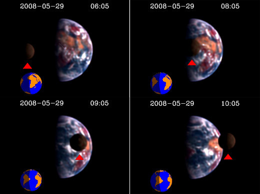
“[포토]외계인이 본 ‘지구와 달?’ …NASA 이색 사진
기사입력 2008-07-18 14:13 |최종수정 2008-07-18 15:57
[동아닷컴]
미국 항공우주국(NASA)이 17일(현지 시간) 혜성 탐사선 ‘딥 임팩트(Deep Impact)’호가 지구로부터 3100만 마일(약 5000만 킬로미터) 떨어진 곳에서 촬영한 달과 지구 사진을 공개했다. 이 사진은 달이 지구를 정면으로 지나가는 연속사진이다. 빨간색 화살표 위가 달의 모습이다.“
사진 제공=NASA <동아닷컴>
(출처: 동아일보 &donga.com,
http://news.naver.com/main/read.nhn?mode=LSD&mid=sec&sid1=105&oid=020&aid=0001975431 )
“나사(미국 항공 우주국)의 딥 임팩트호가 지구를 외계 세계로 촬영한다
NASA's Deep Impact Films Earth as an Alien World
07.17.08
(필자의 주: 딥 임팩트는 1998년 5월 16일 개봉된 혜성 충돌에 관한 SF 영화의 제목이다. 영화에서 우주선의 이름을 땄다.)
Nancy Neal-Jones / Bill SteigerwaldNASA Goddard Space Flight Center, Greenbelt, Md.Nancy.N.Jones@nasa.gov / william.a.steigerwald@nasa.gov301 286 0039 / 5017Lee TuneUniversity of Maryland, College Parkltune@umd.edu301 405 4679DC Agle / Carolina MartinezJet Propulsion Laboratory, Pasadena, Calif.agle@jpl.nasa.gov / Carolina.Martinez@jpl.nasa.gov818 393 9011 / 818 354 9382David L. ChandlerMassachusetts Institute of Technology, Cambridge, Mass.dlc1@MIT.EDU617 253-2704
PRESS RELEASE: 08-68
칼리지 파크, 메릴랜드주. -- 나사의 딥 임팩트 우주선은 3천 1백만 마일 떨어진 우주선의 관점에서 본, 지구를 통과하고 있는 소천체인(앞을 지나가는) 달의 비디오를 찍었다. 과학자들은 이 비디오를 외계 세계를 연구하기 위한 기술을 발전시키는 데 사용하고 있다.
COLLEGE PARK, Md. -- NASA's Deep Impact spacecraft has created a video of the moon transiting (passing in front of) Earth as seen from the spacecraft's point of view 31 million miles away. Scientists are using the video to develop techniques to study alien worlds.
“그렇게 먼 곳으로부터 지구의 비디오를 만드는 것은 먼, 지구와 유사한 외계 세계가 우리에게 어떻게 보일 것인가에 대한 통찰력을 줌으로서 우주에 있는 다른 생명체를 품고 있는 행성들을 찾는데 도움을 준다,” 라고 EPOXI 라 부르는 딥 임팩트 확장 임무를 위한 중요한 연구자인, 메릴랜드 대학의 천문학자인 마이클 애헌씨가 말했다.
"Making a video of Earth from so far away helps the search for other life-bearing planets in the Universe by giving insights into how a distant, Earth-like alien world would appear to us," said University of Maryland astronomer Michael A’Hearn, principal investigator for the Deep Impact extended mission, called EPOXI.
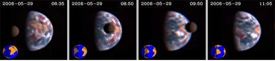
나사의 EPOXI 우주선이 촬영한, 지구를 통과하는 소천체인 달을 보여주는 연속 사진들
Series of images showing the Moon transiting Earth, captured by NASA's EPOXI spacecraft.
Credit: Donald J. Lindler, Sigma Space Corporation/GSFC; EPOCh/DIXI Science Teams
딥 임팩트는 임무 팀이 우주선으로부터 충돌 우주선을 2005년 7월 4일에 템펠 1 혜성 속으로 향하게 했을 때 역사를 만들었다. 나사는 2010년 11월 4일에 하틀리 2 혜성으로 근접 비행하기 위하여 우주선을 재 조정함으로서 최근 그 임무를 확장했다.
Deep Impact made history when the mission team directed an impactor from the spacecraft into comet Tempel 1 on July 4, 2005. NASA recently extended the mission, redirecting the spacecraft for a flyby of comet Hartley 2 on Nov. 4, 2010.
EPOXI는 2가지 확장된 임무 구성 요소를 위한 이름의 조합이다: 태양계 밖 행성 관찰과 특성 찾기(EPOCh)인 하틀리 2 혜성으로 순항하는 동안 외계(태양계 밖) 행성을 찾는 것과, 그리고 딥 임팩트 확장 조사(DIXI)라고 부르는 하틀리 2 혜성으로의 근접 비행.
EPOXI is a combination of the names for the two extended mission components: a search for alien (extrasolar) planets during the cruise to Hartley 2, called Extrasolar Planet Observations and Characterization (EPOCh), and the flyby of comet Hartley 2, called the Deep Impact eXtended Investigation (DIXI).
두 개의 비디오는 지구를 2가지 다른 광파장 길이로 관찰한 것을 보여준다. 자세히 보면 다른 차이가 나는 데, 첫 번째 동영상은 적-녹-청 필터를, 두 번째는 적외선-녹-청 필터를 사용했기 때문이다.
The two videos show Earth observed at different light wavelengths, which is why differences in details are visible. The first version uses a red-green-blue filter; the second, an infrared-green-blue.
Videos credit: Donald J. Lindler, Sigma Space Corporation/GSFC; EPOCh/DIXI Science Teams
비디오 1번
비디오 2번
지구를 완전히 한 바퀴 도는 동안, 딥 임팩트호에서 찍은 화면은 15분의 간격으로 칼라 비디오를 만들기 위하여 합성이 되었다. 비디오가 돌아가는 동안, 달이 한 화면에(달의 공전 운동 때문에) 들어가고 그리고 지구를 통과하고, 그 후에 그 화면을 떠난다. 다른 우주선이 우주로부터 지구와 달을 촬영해 왔다, 그러나 달 위의 큰 분화구와 지구의 대양들과 대륙들이 보이는 충분히 상세하게 지구의 소천체면 통과를 보여주는 것이 딥 임팩트호가 처음이다.
During a full Earth rotation, images obtained by Deep Impact at a 15-minute cadence have been combined to make a color video. During the video, the moon enters the frame (because of its orbital motion) and transits Earth, then leaves the frame. Other spacecraft have imaged Earth and the moon from space, but Deep Impact is the first to show a transit of Earth with enough detail to see large craters on the moon and oceans and continents on Earth.
“이와 비슷한 방식으로 지구를 촬영하기 위하여, 외계 문명은 인간들이 만들기를 꿈꿀 수 있는 한계를 훨씬 뛰어 넘는 기술을 필요로 할 것이다,” 라고 캠브리지 MIT의 행성 이론가이면서 EPOXI의 공동 연구가인 사라 시거씨가 말했다. “그럼에도 불구하고, 나사에서 연구 중인 행성 특성 규정 망원경이 빛의 한 점으로서 지구를 관찰할 수 있다 --- 대륙과 대양이 회전함으로서 보이고 안보이고 함에 따라 시간에 따라 밝기가 변하는 한 점으로.
"To image Earth in a similar fashion, an alien civilization would need technology far beyond what Earthlings can even dream of building," said Sara Seager, a planetary theorist at the Massachusetts Institute of Technology, Cambridge, Mass., and a co-investigator on EPOXI. "Nevertheless, planet-characterizing space telescopes under study by NASA would be able to observe an Earth twin as a single point of light -- a point whose total brightness changes with time as different land masses and oceans rotate in and out of view.
이 비디오는 우리가 아래에 있는 대양, 대륙, 그리고 구름과 함께 행성 빛의 변화하는 점을 연상하는 것을 도와줄 것이다 -- 그리고 외계 태양계 행성에서 해양을 찾는 것은 잠재적으로 거주에 적당한 세계를 확인하는 것을 뜻한다“. 라고 시거 씨는 말했다.
“우리의 비디오는 다른 별들을 공전하는 지구와 유사한 행성들을 관찰하기 위하여 중요한 어떤 독특한 특징들을 보여준다.” 라고 메릴랜드 그린벨트에 소재한 나사의 고다드 항공 비행 센터의 드레이크 데밍씨는 말했다. 데밍씨는 EPOXI의 부원장 연구관이고, 그리고 EPOCh 관찰을 이끌고 있다.
The video will help us connect a varying point of planetary light with underlying oceans, continents, and clouds -- and finding oceans on extrasolar planets means identifying potentially habitable worlds." said Seager. "Our video shows some specific features that are important for observations of Earth-like planets orbiting other stars," said Drake Deming of NASA's Goddard Space Flight Center in Greenbelt, Md. Deming is deputy principal investigator for EPOXI, and leads the EPOCh observations.
“지구의 해양으로부터 반사된 빛에 의한 태양의 반짝임이 비디오에서 볼 수 있다. 그리고 외계 태양계 행성으로부터 관찰되어진 비슷한 반짝임도 외계의 해양을 가리킨다. 또한, 우리는 칼라 복합 영상을 만들기 위하여 보통의 적색 대신에 적외선 광선을 사용했다, 그리고 그것이 땅의 주요부를 더 잘 보이게 했다.” 식물이 더 강하게 근 적외선 영역에서 반사하기 때문에 그런 일이 일어났다, 데밍 씨가 설명한다. 그러므로 이 비디오은 행성이 공전할 때 근 적외선의 강도의 변화를 찾음으로서 외계 태양계상에서 식물이 생장하는 땅의 주요부를 발견하는 가능성을 보여준다.
"A 'sun glint' can be seen in the movie, caused by light reflected from Earth's oceans, and similar glints to be observed from extrasolar planets could indicate alien oceans. Also, we used infrared light instead of the normal red light to make the color composite images, and that makes the land masses much more visible." That happens because plants reflect more strongly in the near-infrared, Deming explained. Hence the video illustrates the potential for detecting vegetated land masses on extrasolar planets by looking for variations in the intensity of their near-infrared light as the planet rotates.
메릴랜드 대학은 하틀리 2 혜성으로 근접 비행을 포함하는 EPOXI 임무를 이끄는 연구 지휘소이다. 나사 고다드는 외계 태양계 행성 관찰을 지휘한다. 캘리포니아 파사데나에 있는 나사의 제트 추진 연구소는 나사의 과학 임무 지휘소를 위하여 EPOXI를 관리한다. 우주선은 콜로라도 부울더에 있는 볼 항공 기술 주식회사에서 나사를 위하여 제작되었다.
The University of Maryland is the Principal Investigator institution, leading the overall EPOXI mission, including the flyby of comet Hartley 2. NASA Goddard leads the extrasolar planet observations. NASA's Jet Propulsion Laboratory, Pasadena, Calif., manages EPOXI for NASA's Science Mission Directorate, Washington. The spacecraft was built for NASA by Ball Aerospace &Technologies Corp., Boulder, Colo.
더 많은 영상과 매스컴
More images and media
이 영상들은 3천 일백만 마일 밖에서 촬영이 되었고 그리고 아주 큰 사진에서 잘라졌기에, 가능한 가장 큰 해상도로 나타난다는 것을 주의 하세요
Please note that these images appear at the largest possible resolution, having been taken from 31 million miles away and cropped from a much larger photograph"
(출처: http://www.nasa.gov/topics/solarsystem/features/epoxi_transit.html )
NASA - NASA's Deep Impact Films Earth as an Alien World
NASA's Deep Impact Films Earth as an Alien World 07.17.08 Nancy Neal-Jones / Bill Steigerwald NASA Goddard Space Flight Center, Greenbelt, Md. Nancy.N.Jones@nasa.gov / william.a.steigerwald@nasa.gov 301 286 0039 / 5017 Lee Tune University of Maryland, Coll
www.nasa.gov
“우리는 얼마나 작은 존재인가”
60억 km 밖에서 본 모래알 지구
기사입력 2007-01-17 17:05 |최종수정 2007-01-17 17:05
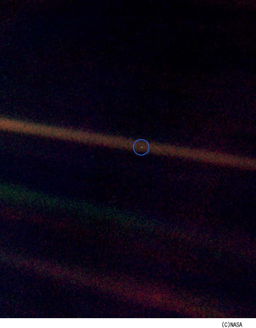
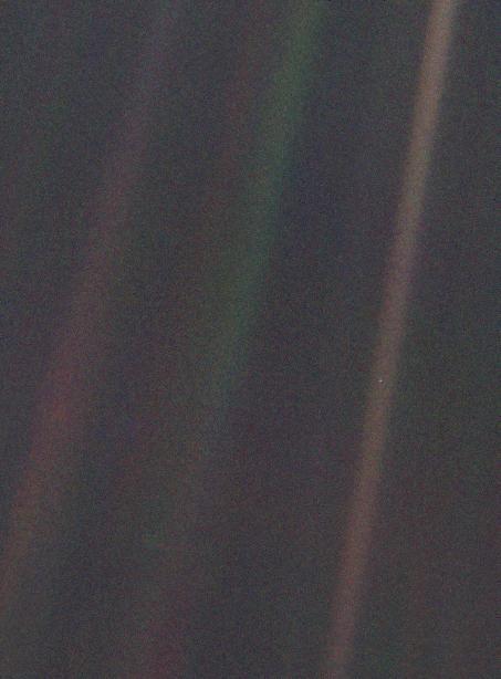
우주 과학도 뿐 아니라 시를 사랑하는 이들도 모두 사랑할 만한, 감동과 깊은 성찰을 일으키는 사진 한 장이다. 사진의 별칭은 ‘창백한 푸른 점 Pale Blue Dot’. 이 사진에 영감을 받아 천문학자 칼 세이건이 쓴 책의 제목이기도 하다.
탐사선 보이저 1호가 1990년 6월 명왕성 부근에서 촬영한 사진 속에서, 지구는 희미한 빛을 내는 작은 점에 불과하다. 16년 전 40억 마일(약 64억 km) 밖에서 촬영한 지구 사진이 아직까지도 해외 네티즌 시선을 거듭 잡아 끄는 이유는 깊은 성찰을 유발하기 때문이다.
칼 세이건은 이 창백한 푸른 점에 대해 다음과 같이 말했다. “여기 있다. 저것이 우리의 고향이다. 저것이 우리다. 우리가 사랑하는 모든 이들, 우리가 알고 있는 모든 사람들, 당신이 들어봤을 모든 사람들, 존재했던 모든 사람들이 그곳에서 삶을 영위했다. 우리의 기쁨과 고통이 총합, 확신에 찬 수많은 종교, 이데올로기들, 경제적 독트린들, 모든 사냥꾼과 약탈자, 모든 영웅과 비겁자, 문명의 창조자와 파괴자, 왕과 농부, 사랑에 빠진 젊은 연인들, 모든 아버지와 어머니, 희망에 찬 아이들, 발명가와 탐험가, 모든 도덕의 교사들, 모든 타락한 정치인들, 모든 슈퍼스타, 모든 최고의 지도자들, 인간 역사 속의 모든 성인과 죄인들이 저기 - 태양 빛 속에 부유하는 먼지의 티끌 위-에서 살았던 것이다.”
말하자면 사진 ‘창백한 푸른 점’은 인간 존재와 인류 역사 그리고 지구가 얼마나 작은지 깨닫게 하고, 사소한 욕망 확신 분노 따위가 덧없는 것임을 절실히 느끼게 만드는 ‘마술적 힘’을 갖고 있다. 때문에 가장 시적이며 철학적인 우주 사진이라 부를 수 있을 것이다. 이나무 기자 (저작권자 팝뉴스)
(출처:
http://news.naver.com/main/read.nhn?mode=LSD&mid=sec&sid1=104&oid=105&aid=0000005669
)
칼 새건의 영어 원문
“창백한 푸른 점
pale blue dot
저 점을 다시 보라. 저 점은 여기, 우리의 집이며, 저 점이 바로 우리이다. 당신이 사랑하는 모든 사람들, 당신이 알고 또 얘기를 들어보았던 모든 사람들, 과거에 존재했던 모든 인간들이 그 점 위에서 그들의 삶을 살았다. 우리의 모든 기쁨과 괴로움, 자신에 가득 찬 수천 개의 종교, 이념들과 경제적 교리들 , 모든 사냥꾼과 약탈자, 모든 영웅과 겁쟁이, 모든 문명의 창조자와 파괴자, 모든 왕과 백성들, 사랑에 빠진 젊은 연인들, 모든 부모와 희망에 찬 어린이, 발명가와 탐험가, 모든 윤리선생, 모든 부패한 정치가들, 모든 슈퍼 스타들, 모든 훌륭한 지도자들, 모든 성인과 죄인들이 인간의 역사 속에서 거기, 바로 태양 빛에 떠도는 먼지 조각 위에서 살았다.
Look again at that dot. That's here. That's home. That's us. On it everyone you love, everyone you know, everyone you ever heard of, every human being who ever was, lived out their lives. The aggregate of our joy and suffering, thousands of confident religions, ideologies, and economic doctrines, every hunter and forager, every hero and coward, every creator and destroyer of civilization, every king and peasant, every young couple in love, every mother and father, hopeful child, inventor and explorer, every teacher of morals, every corrupt politician, every "superstar," every "supreme leader," every saint and sinner in the history of our species lived there--on a mote of dust suspended in a sunbeam.
광활한 우주 경기장에서 지구는 아주 작은 무대에 불과하다. 저 조그만 점의 일부분을 영광과 승리 속에서 아주 잠시 차지하기 위해 장군들과 황제들이 만들어냈던 피로 물든 강들을 생각해보라. 분간해낼 수 조차 없는 어느 한 구석에 사는 주민들이 분간되지 않는 다른 구석에 사는 다른 주민들에게 행했던 끝없는 잔인함을, 얼마나 자주 오해를 하며, 얼마나 기를 쓰고 서로를 죽이려 하는지, 그들의 증오가 얼마나 극심한지 생각하라.
The Earth is a very small stage in a vast cosmic arena. Think of the rivers of blood spilled by all those generals and emperors so that, in glory and triumph, they could become the momentary masters of a fraction of a dot. Think of the endless cruelties visited by the inhabitants of one corner of this pixel on the scarcely distinguishable inhabitants of some other corner, how frequent their misunderstandings, how eager they are to kill one another, how fervent their hatreds.
우리들이 우주에서 특권을 가진 위치에 있다고 생각하는 우리의 태도, 자만심과 망상은 이 창백한 빛의 점에 의해 도전받는다. 거대하게 드리운 우주의 어둠속에서 우리의 행성은 고독한 작은 조각이다. 이 거대한 우주 속에 묻힌 우리의 불명확함 속에서, 우리를 우리자신으로부터 구해내기 위한 도움의 손길이 어디선가 나타날 것이라는 단서는 어디에도 없다.
Our posturings, our imagined self-importance, the delusion that we have some privileged position in the Universe, are challenged by this point of pale light. Our planet is a lonely speck in the great enveloping cosmic dark. In our obscurity, in all this vastness, there is no hint that help will come from elsewhere to save us from ourselves.
지구는 현재까지 알려진 바로는 생명체가 살 수 있는 유일한 세계이다. 적어도 가까운 미래까지는 인간이라는 종족이 이주할 수 있는 곳은 아무 데도 없을 것이다. 방문하는 것은 가능하나, 아직 거주를 할 수 있는 것은 아니다. 좋던 싫던, 당분간은 지구가 우리가 있어야 할 곳이다.
The Earth is the only world known so far to harbor life. There is nowhere else, at least in the near future, to which our species could migrate. Visit, yes. Settle, not yet. Like it or not, for the moment the Earth is where we make our stand.
천문학은 겸허하고 인격을 함양하는 경험이라고 말해져 왔다. 우리의 작은 세계를 멀리서 보여주는 이러한 사진보다 인간 자만심의 어리석음을 더 잘 보여줄 수 있는 것은 아마도 없을 것이다. 서로에게 더욱 친절히 대하고, 우리의 유일한 고향인 창백한 푸른 점을 보존하고 아끼는 것은 우리의 책임이라는 것을 강조하고 싶다.
It has been said that astronomy is a humbling and character-building experience. There is perhaps no better demonstration of the folly of human conceits than this distant image of our tiny world. To me, it underscores our responsibility to deal more kindly with one another, and to preserve and cherish the pale blue dot, the only home we've ever known.
칼 새건, 창백한 푸른 점
- Carl Sagan, Pale Blue Dot, 1994“
(출처: http://baekis.egloos.com/1764206 )
NASA 제트 추진 연구소(Jet Propulsion Laboratory)의 이 사진에 대한 설명
(사진 출처: http://photojournal.jpl.nasa.gov/jpegMod/PIA00452_modest.jpg )
‘창백한 푸른 점’이라고 이름 붙여진 지구의 협각 컬러 사진은 보이저 1호가 촬영한 첫 번째 태양계 사진 중의 일부분이다. 보이저 1호는 지구에서 40억 마일 이상 떨어져있는, 황도 위 32도 지점에서 태양계 모자이크를 위해 총 60장의 사진을 찍었다. 보이저 호가 지구와 매우 멀리 떨어져 있었으므로, 협각 카메라에서조차도 지구는 화상요소의 크기보다 작은 단순한 점광일 뿐이었다. 지구는 크기가 0.12 픽셀에 불과한 초승달모양이었다. 동시에, 태양에 근접하여 사진을 찍었기 때문에 지구는 산란 광선 중 하나의 한가운데 놓여 있었다. 지구의 확대사진을 보라색, 파란색, 녹색 3가지의 칼라 필터를 통과시키고 재조합시켜 칼라 사진을 만들어냈다. 사진 배경은 확대를 하였기 때문에 기인한 인공적인 것이다.”
"This narrow-angle color image of the Earth, dubbed 'Pale Blue Dot', is a part of the first ever 'portrait' of the solar system taken by Voyager 1. The spacecraft acquired a total of 60 frames for a mosaic of the solar system from a distance of more than 4 billion miles from Earth and about 32 degrees above the ecliptic.
From Voyager's great distance Earth is a mere point of light, less than the size of a picture element even in the narrow-angle camera. Earth was a crescent only 0.12 pixel in size. Coincidentally, Earth lies right in the center of one of the scattered light rays resulting from taking the image so close to the sun. This blown-up image of the Earth was taken through three color filters -- violet, blue and green -- and recombined to produce the color image. The background features in the image are artifacts resulting from the magnification."
(출처: 나사/제트추진연구소, NASA/JPL,
http://photojournal.jpl.nasa.gov/catalog/PIA00452 )
Catalog Page for PIA00452
This narrow-angle color image of the Earth, dubbed 'Pale Blue Dot', is a part of the first ever 'portrait' of the solar system taken by Voyager 1. The spacecraft acquired a total of 60 frames for a mosaic of the solar system from a distance of more than 4
photojournal.jpl.nasa.gov
"가장 먼 곳서 촬영된 지구! 15억km 토성에서 본 지구 모습 화제
기사입력 2006-09-25 12:02
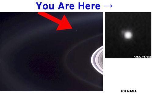
지구에서 15억km 떨어진 우주에서 ‘한 점’으로 포착된 지구 사진이 해외 네티즌들의 눈길을 사로잡고 있다. 최근 미국 항공우주국(NASA)가 공개한 화제의 사진은 토성 우주탐사선 카시니호가 촬영한 것으로, 지구에서부터 15억km 떨어진 곳에서 포착한 지구의 모습을 담고 있다.
지금까지의 ‘지구 사진’ 중 가장 먼 곳에서 촬영된 것으로 알려진 이 사진에서 지구는 ‘하나의 흐릿한 점’에 불과하다. 카시니호가 촬영한 ‘지구 사진’은 21일 BBC 등 해외 언론에 소개되기도 했는데, 카시니호는 지금까지 알려지지 않은 토성의 ‘고리’ 또한 발견했다고 언론들은 설명했다. 지난 1997년 10월 지구를 출발한 카시니호는 2004년 7월 토성 궤도 진입에 성공해 활발한 탐사활동을 진행하고 있는 중."
(사진 : 카시니호에서 바라 본 지구의 모습, NASA 홈페이지)
이상범 기자 (저작권자 팝뉴스)
NASA 제트 추진 연구소(JPL, Jet Propulsion Laboratory)의 이 사진에 대한 설명
“창백한 푸른 천체 2006년 9월 19일
Pale Blue Orb 09.19.06
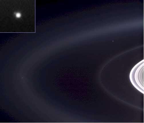
나사의 보이저 1호가 우리의 고향인 지구를 해왕성보다 더 먼 궤도로부터 한 개의 창백한 푸른 점으로 본 이후로 태양계 외행성계를 넘어선 거리에서 찍은 지구의 칼라 사진은 없었다. 지금 카시니호는 우리 고향 행성에 강력한 눈을 투사했고, 그리고 토성 주위에서 지구를 사진으로 잡았다-한 개의 창백하고 푸른 점-그리고 희미한 달을 암시하는 사진.
Not since NASA's Voyager 1 spacecraft saw our home as a pale blue dot from beyond the orbit of Neptune has Earth been imaged in color from the outer solar system. Now, Cassini casts powerful eyes on our home planet, and captures Earth, a pale blue orb -- and a faint suggestion of our moon
태양의 정면으로 토성이 지나감에 따라 카시니호가 지구를 찍을 수 있게 된 자연스런 칼라 초상화같이 지구가 여기에 찍혔다. 우주선에 장착된 카메라와 기계들이 태양의 섬광으로부터 보호받는 것 없이 그것의 탄생지를 향하기 위하여 가까스로 태양으로부터 지구가 분리되었다.
-- among the glories of the Saturn system. Earth is captured here in a natural color portrait made possible by the passing of Saturn directly in front of the sun from Cassini’s point of view. At the distance of Saturn’s orbit, Earth is too narrowly separated from the sun for the spacecraft to safely point its cameras and other instruments toward its birthplace without protection from the sun’s glare.
중앙 상단의 사진의 우측 편에 밝은 푸른 점으로 지구와 달이 보인다. 여기서, 카시니호는 대서양과 북아프리카 서부 해안을 내려다 보고 있다. 카시니호에서 본 지구의 위상 각도는 약 30도이다.
The Earth-and-moon system is visible as a bright blue point on the right side of the image above center. Here, Cassini is looking down on the Atlantic Ocean and the western coast of north Africa. The phase angle of Earth, seen from Cassini is about 30 degrees.
확대된 사진은 모노크롬 필터를 사용하여 찍었고, 지구의 좌측 상단에 어두운 돌출부는 달을 나타낸다. 카시니호의 카메라를 통하여 태양계 외행성계에서 본 직접적인 인간의 경험 전체 폭은 겨우 몇 픽셀에 지나지 않는다.
A magnified view of the image taken through the clear filter (monochrome) shows the moon as a dim protrusion to the upper left of Earth. Seen from the outer solar system through Cassini’s cameras, the entire expanse of direct human experience, so far, is nothing more than a few pixels across.
몇몇 다른 천체가 그들의 지표면 아래에 물을 가지고 있을 가능성을 암시하는 것 같이, 지구는 더 이상 태양계에서 유일하게 물를 가지고 있는 존재라는 특징을 유지하지 못한다. 토성의 달인 엔셀라두스(Enceladus)가 그들 중의 하나이다. 그리고 이 사진의 왼쪽에 얼음 파편의 장식과 얼음으로 이루어진 푸른 E 링을 동여매고 있는 엔셀라두스가 찍혔다. 미묘한 물질의 손가락이 활동적인 달에서 E 링 속으로 연장된다. 새로 밝혀진 특징들을 상세하게 보려면 PIA08321을 보라
Earth no longer holds the distinction of being our solar system’s only “water world,” as several other bodies suggest the possibility that they too harbor liquid water beneath their surfaces. The Saturnian moon, Enceladus, is among them, and is also captured on the left in this image (see inset), with its plume of water ice particles and swathed in the blue E ring which it creates. Delicate fingers of material extend from the active moon into the E ring. See PIA08321, for a more detailed view of these newly-revealed features.
좁고 미약한 G 링과 주 링은 우측 편에 보인다.
이 사진은 링의 조명되지 않은 쪽의 위에서 약 15도 각도로부터 내려다보았다.
The narrow tenuous G ring and the main rings are seen at the right.
The view looks down from about 15 degrees above the un-illuminated side of the rings.
이 사진은 적색, 녹색, 그리고 청색의 스팩트럼 필터를 사용하여 찍었고, 이 사진을 만들기 위하여 결합되었다. 이 사진은 2006년 9월 15일 토성으로부터 약 210만 Km 그리고 태양과 카시니호와는 179도의 각도로 카시니호의 와이드 앵글 카메라로 찍었다. 사진의 배율은 대략 픽셀 당 250Km이다.
Images taken using red, green and blue spectral filters were combined to create this view. The image was taken by the Cassini spacecraft wide-angle camera on Sept. 15, 2006, at a distance of approximately 2.1 million kilometers (1.3 million miles) from Saturn and at a sun-Saturn-spacecraft angle of almost 179 degrees. Image scale is approximately 250 kilometers (155 miles) per pixel. At this time, Cassini was nearly 1.5 billion kilometers (930 million miles) from Earth.
이때 카시니호는 지구와 약 15억 Km 떨어져 있었다. 카시니-후이겐스 미션은 나사, 유럽 항공국 그리고 이태리 항공국과의 협동 프로젝트였다. 파사데나에 위치한 캘리포니아 공과대학(California Institute of Technology)의 분과로서 제트 추진 연구소(Jet Propulsion Laboratory)가 워싱턴에 위치한 NASA's Science Mission Directorate를 위하여 임무를 수행했다. 카시니 궤도 비행체와 탑재된 2대의 카메라는 제트 추진 연구소에서 설계되고, 개발되고, 그리고 조립되었다.
The Cassini-Huygens mission is a cooperative project of NASA, the European Space Agency and the Italian Space Agency. The Jet Propulsion Laboratory, a division of the California Institute of Technology in Pasadena, manages the mission for NASA's Science Mission Directorate, Washington, D.C. The Cassini orbiter and its two onboard cameras were designed, developed and assembled at JPL.
사진 판독 지휘 센터는 콜로라도 주의 부울더에 있는 우주 과학 연구소에 위치하고 있다.“
The imaging operations center is based at the Space Science Institute in Boulder, Colo.
For more information about the Cassini-Huygens mission visit http://saturn.jpl.nasa.gov .The Cassini imaging team homepage is at http://ciclops.org .
Credit: NASA/JPL/Space Science Institute
(출처: http://www.nasa.gov/mission_pages/cassini/multimedia/pia08324.html )
NASA - Pale Blue Orb
Not since NASA's Voyager 1 spacecraft saw our home as a pale blue dot from beyond the orbit of Neptune has Earth been imaged in color from the outer solar system. Now, Cassini casts powerful eyes on our home planet, and captures Earth, a pale blue orb -- a
www.nasa.gov
카시니 호가 찍은 토성 사진
(사진 출처:
http://saturn.jpl.nasa.gov/multimedia/poll/images/PIA08329-brPoll.jpg )
Overview | Cassini – NASA Solar System Exploration
NASA’s real-time science encyclopedia of deep space exploration. Our scientists and hardworking robots are exploring the wild frontiers of our solar system.
solarsystem.nasa.gov
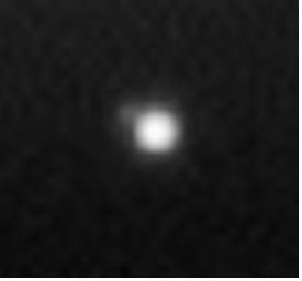
카시니 호가 찍은 토성 사진의 확대 사진
중앙 우측 부근 토성의 고리 상단 부분에 보이는 조그만 흰점이 지구이다.
"은하계에서 우리 태양계의 위치
Our Solar System's Location in the Milky Way Galaxy
지구로부터, 우리의 은하계는 밤하늘을 가로질러 뻗어있는 은하수띠로 보인다. 당신이 밝은 도시의 빛으로부터 멀리 떨어지면 쉽게 볼 수 있다.
From the Earth, our Milky Way Galaxy is visible as a milky band that stretches across the night sky. It is easier to see when you are far from bright city lights.

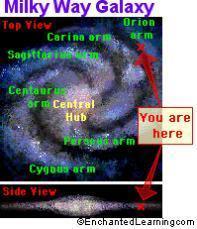
우리의 태양계는 소용돌이 모양의 은하인 은하계의 바깥 구역에 위치해 있다. 은하계는 대략 2천억 개의 별들을 포함하고 있다. 이 별들중 대분은 지구에서는 보이지 않는다. 우리가 하늘에서 볼 수 있는 거의 모든 것은 은하계에 속한다.
Our solar system is located in the outer reaches of the Milky Way Galaxy, which is a spiral galaxy. The Milky Way Galaxy contains roughly 200 billion stars. Most of these stars are not visible from Earth. Almost everything that we can see in the sky belongs to the Milky Way Galaxy.
태양은 8 만에서 12 만 광년의 직경을 가진(약 7 천 광년보다 약간 적은 두께) 은하계 중심으로부터 2 만 6 천 광년에 있다. 우리들은 바깥으로 향한 끝머리인 하나의 소용돌이 모양으로 생긴 팔위에 위치해 있다. 은하수를 한 바퀴 공전하는 데 태양(그리고 우리의 태양계)이 대략 2 억-2 억 5 천 만년 걸린다. 우리는(그리고 나머지 태양계)는 약 초속 155 마일(시속 250 Km)의 속도로 여행하고 있다.
The sun is about 26,000 light-years from the center of the Milky Way Galaxy, which is about 80,000 to 120,000 light-years across (and less than 7,000 light-years thick). We are located on on one of its spiral arms, out towards the edge. It takes the sun (and our solar system) roughly 200-250 million years to orbit once around the Milky Way. In this orbit, we (and the rest of the Solar System) are traveling at a velocity of about 155 miles/sec (250 km/sec).
지구를 출발하여 은하계의 중심에 도달하기 위해서는, 궁수 자리를 향하여 목표를 잡는다. 당신이 우주선에 타고 있다면, 여행 동안 당신은 차례 차례로(그리고 많은 다른 별들을!) 궁수 자리에 있는 별들을 지나가게 된다.
To reach the center of the Milky Way Galaxy starting from the Earth, aim toward the constellation Sagittarius. If you were in a spacecraft, during the trip you would pass the stars in Sagittarius one by one (and many other stars!).
은하계
당신은 여기에 있다.
우리는 은하계 내부에 있고 그리고 은하계 외부로 우주선을 결코 보내지 않았기 때문에, 은하계의 사진을 가지고 있지 않다. 그러나 전파 망원경은 가지고 있기에, 은하계에 대하여 많은 것을 알게 해준다.
Since we're inside the Milky Way Galaxy and we've never sent a spacecraft outside our Galaxy, we have no photographs of the Milky Way Galaxy. Radio telescope data does, however, let us know a lot about it.
은하계의 팔들은 그들이 보이는 방향에 있는 별자리에 따라 명명되었다. 은하계의 중요한 팔들은 페르세우스 자리 팔, 켄타우르스 자리 팔, 그리고 백조자리 팔이다; 우리 태양계는 오리온 돌출부라고 불리는 하나의 조그만 팔 내부에 위치한다. 중앙 축(중앙 부풂)은 늙은 별들을 그리고 최소한 한 개의 블랙홀을 포함하고 있다; 젊은 별들은 새로운 별들을 형성하는 먼지와 가스를 따라서 팔 내부에 있다.
The arms of the Milky Way are named for the constellations that are seen in those directions. The major arms of the Milky Way galaxy are the Perseus Arm, Sagittarius Arm, Centaurus Arm, and Cygnus Arm; our Solar System is in a minor arm called the Orion Spur. The central hub (or central bulge) contains old stars and at least one black hole; younger stars are in the arms, along with dust and gas that form new stars.
큰 갈라진 틈은 은하계에 있는 어둡고, 희미한 먼지 구름들의 연속이다. 이들 구름들은 궁수 자리에서부터 백조 자리까지 뻗어 있다.
The great rift is a series of dark, obscuring dust clouds in the Milky Way. These clouds stretch from the constellation Sagittarius to the constellation Cygnus.
은하계는 국부 은하단이라 불리는 은하의 집단 중에서 단지 하나의 은하이다.국부 은하단에서 은하계는 초속 약 3 백 Km로 (처녀 자리를 향해) 움직이고 있다. 은하계는 국부 은하단내에서(국부 은하단이란 “허블의 흐름 팽창”과 독립적으로, 서로 조화하여 움직이고 있는 가까운 은하들이라고 정의 되어 진다) 다른 은하들과 조화하여 움직이고 있다.
The Milky way Galaxy is just one galaxy in a group of galaxies called the Local Group. Within the Local Group, the Milky Way Galaxy is moving about 300 km/sec (towards the constellation Virgo). The Milky Way Galaxy is moving in concert with the other galaxies in the Local Group (the Local Group is defined as those nearby galaxies that are moving in concert with each other, independent of the "Hubble flow" expansion).
미국의 천문학자인 하를로우 새플리(1885년 11월 2일 - 1972년 10월 20일)가 은하계의 크기와 은하계 내에서의 우리의 위치를(약 1918년) 측정한 첫 번째 사람이었다.
Harlow Shapley (November 2, 1885- October 20, 1972), an American astronomer, was the first person to estimate the size of the Milky Way Galaxy, as well as our position in the galaxy (about 1918).
(출처: http://www.enchantedlearning.com/subjects/astronomy )
All About Astronomy
All About Astronomy; learn about the stars, galaxies, our Sun, the planets, moon, asteroids, comets, meteoroids, the Kuiper belt, Oort cloud, and the Milky Way.
www.EnchantedLearning.com